| | << North |
 |
It
is historically recorded that Egypt was the first country to dig a
man-made canal across its lands to connect the Mediterranean sea to the
Red sea via the River Nile and its branches, and the first who dug it
was Senausert III, Pharaoh of Egypt (1874 B.C.) . This canal was
abandoned to silting and reopened several times as follows: - The canal of Sity I | 1310 B.C. | - The canal of Nkhaw | 61 B.C. | - The canal of Darius I | 510 B.C. | - The canal of Ptolemy II | 285 B.C. | - The canal of the Romans (Emperor Trajan) | 117 B.C. | - The canal of Amir El Moemeneen | 640 A.D. |
- The Suez canal is actually the first canal directly linking the Mediterranean sea to the Red sea. It was opened for international navigation on 17 November 1869.
- Egypt nationalized its canal on 26 July 1956
- The canal was closed five times, the last time was for 8 years (1967-1975) and was reopened in 1975

 Development of Suez Canal Development of Suez Canal ITEM | UNIT | 1869 | 1956 | 1962 | 1980 | 1994 | 1996 | 2001 | 2008 | Percentage increase (1869-2001) | WIDTH AT 11M DEPTH | M | 44 | 60 | 90 | 160 | 210 | 210 | 210 | 210 | 477% | MAX DRAFT OF SHIPS | FEET | 22 | 35 | 38 | 53 | 56 | 58 | 62 | 68 | 282% | OVERALL LENGTH | KM | 164 | 175 | 175 | 190.25 | 190.25 | 190.25 | 190.25 | 190.25 | 116% | DOUBLED PARTS | KM | - | 29 | 29 | 78 | 78 | 78 | 78 | 78 | 269% | WATER DEPTH | M | 10 | 14 | 15.5 | 19.5 | 20.5 | 21 | 22.5 | 23.5 | 225% | CROSS SECTIONAL AREA | M2 | 304 | 1100 | 1800 | 3600 | 4300 | 4500 | 4800 | 4800 | 1579% | MAX. TONNAGE (DWT) | TON | 5000 | 30,000 | 80,000 | 150,000 | 180,000 | 185,000 | 210,000 | 210.000 | 4200% |
|
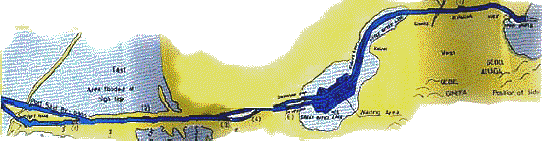
Characteristics of the current canal Overall length | 193 km | From the fairway buoy to Port Said lighthouse | 22.5 km | From the waiting area to the southern entrance | 15 km | From Port Said to Ismailia | 78.5 km | From Ismailia to Port Tawfik | 83.65 km | The length of doubled parts | 68 km | Width at water level | 300/365 m | Width between buoys | 180/205 m | Maximum permissible draught for ships | 68 ft. | The canal depth | 21m | Maximum permissible air draft | 68 m | Cross sectional area | 4500/4800 m2 |
Advantages of the Suez Canal
- Longest canal in the world with no locks
- Compared with other waterways, the percentage of accidents is almost nil.
- Navigation goes day and night
- Liable to be widened and deepened when required to cope with the expansion in ship sizes.
Trade route saving
The
geographical position of the Suez Canal makes it the shortest route
between East and West as compared to the “Cape of Good Hope”. The Canal
route achieves a saving in distance between the ports north and south
the Canal, the matter that is translated into other savings in time,
fuel consumption and ship operating costs as shown in the table below: * Saving In Distance (Suez Canal & Cape)
From | To | Distance (N. Miles) | Saving
% | S. C. | CAPE | Ras Tanura | Constantza | 4,144 | 12,094 | 66 | Lavera | 4,684 | 10,783 | 57 | Rotterdam | 6,436 | 11,169 | 42 | New York | 8,281 | 11,794 | 30 | Jeddah | Piraeus | 1,320 | 11,207 | 88 | Jeddah | Liverpool | 3,902 | 10,702 | 63.5 | Bombay | Rotterdam | 6,337 | 10,743 | 41 | Bombay | Marseille | 4,558 | 10,362 | 56 | Shanghahai | Genoa | 8,670 | 13,619 | 36.3 |
Suez Canal Transit Tolls
The following table indicates the Suez canal transit dues taking effect as of January 1,1999.
Further facilities and privileges are to be granted as explained below.
click here for an easy way to calculate Suez Canal transit tolls RATES OF TRANSIT DUES TO BE APPLIED FROM 01/04/2008 All figures is based on SDR (see below) | | Suez Canal Suez Canal net tonnage net tonnage | Vessel type | Condition | First
5000 | Next
5000 | Next
10000 | Next
20000 | Next
30000 | Next
50000 | Rest | | | 7,65 | 4,80 | 3,90 | 1,70 | 1,50 | 1,40 | 1,30 | | | 6,50 | 4,08 | 3,32 | 1,45 | 1,28 | 1,19 | 1,11 | Tankers of Petroleum Products | | 7,65 | 4,80 | 3,90 | 2,35 | 2,30 | 2,20 | 2,10 | | | 6,50 | 4,08 | 3,32 | 1,45 | 1,28 | 1,19 | 1,11 | | | 7,65 | 5,20 | 4,40 | 1,40 | 1,30 | 1,25 | 1,20 | | | 6,50 | 4,42 | 3,74 | 1,19 | 1,11 | 1,06 | 1,02 | | | 7,65 | 4,90 | 3,90 | 2,80 | 2,60 | 2,50 | 2,50 | | | 6,50 | 4,17 | 3,32 | 2,38 | 2,21 | 2,13 | 2,13 | | | 7,65 | 5,30 | 4,90 | 3,40 | 3,30 | 3,20 | 3,10 | | | 6,50 | 4,51 | 4,17 | 2,89 | 2,81 | 2,72 | 2,64 | Chemical and Other Liquid Bulk | | 8,00 | 5,50 | 4,70 | 3,00 | 2,90 | 2,80 | 2,80 | | | 6,80 | 4,68 | 4,00 | 2,55 | 2,47 | 2,38 | 2,38 | | | 7,65 | 5,00 | 4,00 | 2,80 | 2,60 | 2,05 | 1,95 | | | 6,50 | 4,25 | 3,40 | 2,38 | 2,21 | 1,74 | 1,66 | | | 7,65 | 5,50 | 4,00 | 3,00 | 2,90 | 2,85 | 2,80 | | | 6,50 | 4,68 | 3,40 | 2,55 | 2,47 | 2,42 | 2,38 | | | 7,65 | 5,30 | 4,30 | 3,10 | 2,90 | 2,80 | 2,70 | | | 6,50 | 4,51 | 3,66 | 2,64 | 2,47 | 2,38 | 2,30 | | | 7,65 | 5,00 | 3,85 | 2,75 | 2,60 | 2,05 | 1,95 | | | 6,50 | 4,25 | 3,27 | 2,34 | 2,21 | 1,74 | 1,66 | | | 7,65 | 5,00 | 4,30 | 3,05 | 3,00 | 2,90 | 2,80 | | | 6,50 | 4,25 | 3,66 | 2,59 | 2,55 | 2,47 | 2,38 | | | 8,30 | 5,10 | 4,80 | 3,40 | 3,20 | 2,90 | 2,80 | | | 0,00 | 0,00 | 0,00 | 0,00 | 0,00 | 0,00 | 0,00 | | | 8,00 | 5,00 | 4,40 | 3,20 | 3,10 | 2,90 | 2,80 | | | 6,80 | 4,25 | 3,74 | 2,72 | 2,64 | 2,47 | 2,38 |
- If in ballast, chemical / oil tankers are to be charged at the same rate of Ballast Oil Tankers.
- If in ballast, combined carriers are to be charged at the same rate of Ballast Dry bulk carriers.
The special drawing right SDR is
an international reserve asset created by the International Monetary
Fund to supplement existing reserves. It is valued on the basis of a
basket of five currencies and can be used in a wide variety of
transactions and operations among official holders.
Useful transit information -
Master to try his best to adjust the non used double bottom tanks
to read 6 inches or less in order to be considered as an empty tanks which will be exempted from Suez Canal Net Tonnage. - Water Ballast tanks will be exempted from Suez Canal Net Tonnage. - Minimum transit speed through the Canal is 14 km/hour, the following extra tolls will be levied in case the transit speed will be less than 14 km/hour: Ship’s speed is less than the speed of: The group but not more than | Additional tolls | 1 km/hour | 10% of the transit tolls | 2 km/hour | 20% of the transit tolls | 3 km/hour | 30% of the transit tolls | 4 km/hour | 40% of the transit tolls | 5 km/hour | 80% of the transit tolls | 6 km/hour or more | 160% of the transit tolls |
-Vessel transiting the Canal should be equipped with open mooring boats or lifting appliances of minimum 2 tons lifting capacity otherwise, the Suez Canal authority will apply imposed tug of SDR 17,000 (about USD27,000). -Imposed
tug of SDR 17,000 (about USD 27,000) might be applied in case of
vessel's age over 25 years subject to SC pilot trial and previous
transit record of the vessel.
Convoy System
A - Northbound Convoy: (1) Starts at 0600 at Km. 160 and consists of two groups of vessels. Group A:
I
- Navy ships, 4th Generation Containerships, 3rd Generation
Containerships over 40.000 SC.G.T. & similar, LASH over 35.000
SC.G.T. LPG and LNG (Loaded or N.G.F) and loaded chemicals carriers Ii - Loaded VLCC'S, conventional loaded Tankers and Bulk carriers (Draught over 38 feet or length over 950 feet B.P.) Group B: Cargo and other vessels anchored in Suez Anchorage's. N.B.:
For safety measures, L,.P.G. and L.N.G . Vessels, in ballast or loaded
and loaded chemicals in bulk are included in the Loaded Tankers group.
(2)
The North bound convoy has a free run from Port of Suez till Port-Said.
It passes through the East Kabrit channel, the Eastern dredged channel
in the Bitter Lakes, the East channel of the Deversoir, the East
channel of Lake Timsah, the East channel of Ballah loop and the East
channel from KM. 17 Northward. (3)
In case the northbound convoy has to stop in the Bitter Lakes due to
traffic situation of southbound convoy or emergency, the following must
be considered: Container vessels heading the convoy will drop anchor in the suitable East Anchorage Areas of the Bitter Lakes.
VLCC's will anchor in the suitable East Anchorage according to their draught.
All other vessels will anchor in the East Area corresponding to their draught.
Three berths are available in Kabrit East Branch in case of emergency.
NOTE:
L.P.G., L.N.G. in ballast or loaded, and chemicals loaded in bulk For
safety measures, they are included in the Tankers Group. B - Southbound First Convoy (N1) (1) Starts from 0000 hrs to 0500 hrs and consists of 3 groups of vessels Group A : Vessels in Port Said Harbor.
Group
B : Vessels anchored in the Northern Anchorage Area consisting of 4th
Generation Containerships, 3rd Generation Containerships, VLCC's in
ballast over 42 feet draught, LPG, LNG, N.G.F(LPG, LNG, N.G.F. vessels may join group A.) .
vessels in ballast or loaded and LASH over 35.000 SC. G.T. This group
will be headed by the Containerships and the first vessel will enter
through Port Said East Approach channel in due time to join Group A at
Km. 17.
Group C : Vessels anchored in Southern Anchorage Area will
enter through Port Said West channel in due time to join Group B at Km.
17.
(2)
This convoy has a free run to the Bitter Lakes, passes through the East
branch of Ballah by-pass, the East channel of Lake Timsah, the
Deversoir West channel and anchors in the Western Anchorage's in Bitter
Lakes. (3)
The sequence of continue route from the Bitter Lakes will be Warships,
LPG, LNG vessels, the 4th Generation Containerships, 3rd Generation
Containerships over 40.000 SC.G. And LASH over 35.000 SC. G.T. followed
by VLCC's in ballast and then other vessels. The first ship of the
southbound convoy will regulate speed to cross the last northbound
vessel abeam of Kabrit station. C - Southbound Second Convoy (N2): (1)
Starts from 0630 hrs to 0900 hrs. The forming and depth of this convoy
is subject to situation of traffic and limit time. A third group may
enter Canal from 0300 to 0430 hours according to traffic situation.
(2)
3rd & 4th Generation Container ships with more than one propeller
astern shall be ahead of this convoy to anchor at Temsah Lake (maximum
two vessels).
(3) Vessels will make fast in Ballah West Branch (Maximum capacity 15 vessels according to the NR. of berths at Ballah Loop.), and continue route after the last Northbound vessel clears Km. 61.
(4)
Dimensions of vessels that can make fast at Ballah West Branch should
not exceed those indicated in the following table, excluding Tankers
over 90000 Tons SC.G.T.
(5) Vessels not allowed to join this convoy are the following: Loaded
Tankers (or Bulk carriers) carrying Petroleum Grade A or similar
substances (Flash point below 23ºC or 73ºF, ascertained by an open test
or any equal degree of accuracy).
Liquefied inflammable gas vessels (LPG, LNG, or similar Loaded or Ballast N.G.F. vessels).
Vessels not fitted with double bottom carrying chemicals in bulk.
Vessels carrying radioactive substance Group 1.
Vessels carrying dangerous wastes.
Heavy
lifters (semi-submersible) carrying heavy lift units with tonnage
exceeding the lifting capacity of their individual cranes.
Vessels carrying deck cargo protruding more than what is stated in Art. 26 of these Rules.
Suez
Canal Authority decided the limit time for arrival to join the convoys
will be on the basis of passing the following latitudes: At Port Said: (South of Lat. 31' 28.7" N)
At Suez:
A-Tankers group (North of Lat. 29' 42.8" N)
B- Other vessels: (North of Lat. 29' 48.33 N)
Following vessels which intend to join the south bound convoy are not allowed for shifting in Port Said inner harbor:
LPG, LNG, laden or ballast N.G.F., and vessels with S.C.GRT over 40,000 or with arrival draft of 38 and over.
Pre-arrival information Note
that either north or south bound, masters to ensure sending regular
arrival notices 5,3,2 days and 24 hours before arrival to S.C.A.
and to our office (Rafimar) The necessary information for your transit: Vessel name, Ex name and nationality/call sign/type. Date of last transit and if there is any changes done to vessel's particulars. Int'l GRT/NRT/S.C.NRT Max. arrival draft /LOA/breadth. Next-last call/ETA Vessel status (Laden/Ballast) and cargo on board If carrying dangerous cargo on board, state quantity, class and UN number If carrying cement cargo, state the quantity.
Upon arrival of indicated positions call Port Said pilot station/boat by VHF Ch. 12/16 to report your arrival and anchor time.
Try
your best to fill the declaration of double bottom tanks which will be
provided by S.C. representatives specially the non used tanks.
Documents Needed for 1st transit A- Documents to be produced are: 1) Suez Canal Special Tonnage Certificate and Calculation Sheets (3 copies in the first transit).
2) Certificate of Registry & ship's drawing.
3) Statistical Declaration.
4)
Extract from the vessel's official documents and information concerning
the vessel's type and her cargo (Containers, barges, etc ...).
5) Declaration concerning the use of double bottom tanks and the lower parts of the high tanks.
6) Declaration concerning vessels in ballast.
7) Declaration of State of Navigability.
8) The last Classification Certificate issued.
9) Any other information necessary for transiting the Canal.
10) Piping plan and general arrangement plan for LPG and LNG vessels.
11)
I.O.P.P International Oil Pollution Prevention Certificate of
Compliance and its supplement for the record of construction and
equipment as amended for tanker vessels.
12) I.S.P.C Certificate. B
- Vessel wishing to transit the Canal must declare at the CA Offices
and pay the various dues mentioned in Part IV Chap. XIII of the present
Rules. She must furnish the CA Officials wit.1-i all the particulars
requested by her agent's. C - The vessel must in addition comply with the requirements of the A.R.E. Government Authorities. D
- In case the CA deems it necessary to be supplied with a new
Seaworthiness Certificate issued by a recognized classification society
belonging to I.A.C.S. Seaworthiness
Certificates to be accepted by SCA, if in native language, are to be
translated into Arabic or English and duly certified by the Embassy or
Consulate in the ARE. E
- Navy ships transiting the SC Waters must be provided with a Suez
Canal Special Tonnage Certificate showing the SC.G. and N.T. If such
document is not on board, the Commanding Officer has to give, in
writing, the following information: Name of Ship.
Name of Commanding Officer.
Call sign of the ship (Radio Call).
L. 0. A., B.O.A. and depth of the ship.
(As
long as the ship is not provided with the SC Special Tonnage
Certificate, transit dues will be levied on the temporary Gross Tonnage
product of the empirical formula without any allowance till the
presentation of the documents required). Mooring Boats: Vessels
transiting the Canal must have mooring boats as mentioned hereafter
hired from the Suez Canal Mooring Company approved by SCA. In
case no mooring (Open type lifeboat )boats from the said company are
available, ship's boats if suitable for mooring in the Canal can be
used and must be manned by shore crew, hired from the SC mooring
company, each boat is to be manned by three men. One mooring boat or one motor boat for vessels under 2500 tons gross, SC.G.T. One motor boat for vessels from 2500 to 5000 tons gross, SC.G.T. Two motor boats or one motor boat and one mooring boat for vessels from 5000 SC.G.T. to 30000 SC.G.T. Two motor boats for vessels over 30000 tons gross, SC.G.T. Ships may ask for additional motor boats or mooring boats according to Master's request.
These
mooring boats must be in constant readiness for lowering to run the
ropes to the mooring posts without any delay during the transit of the
vessel. Ships
must be fitted with well maintained lifting appliances capable of
lifting mooring boats of 4 tons weight (Including crew members). Ships
may carry extra mooring boats as passengers for the interest of
navigation. However, LPG LNG, and Loaded Tankers are not allowed any
extra boats. The handling of mooring boats must be carried out well clear from the ship's propellers. Masters
are requested to reduce speed during lifting or lowering operations of
mooring boats, an officer must be in charge, to avoid accidents that
may endanger the life of mooring men. If
the vessel has no means for lifting mooring boats and ship's boats are
not suitable for mooring in the Canal, the vessel shall not be allowed
to transit the Canal.
|
|
 |